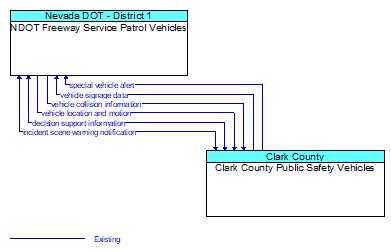
Interface: NDOT Freeway Service Patrol Vehicles - Clark County Public Safety Vehicles
Architecture Flow Definitions
decision support information (Existing)
Information provided to support effective and safe incident response, including local traffic, road, and weather conditions, hazardous material information, and the current status of resources (including vehicles, other equipment, supplies) that have been allocated to an incident.
incident scene warning notification (Existing)
Notification of an incident scene emergency or safety issue. This flow identifies that an incident scene emergency or safety issue has occurred so that warnings may be generated by more than one system in the work zone.
special vehicle alert (Existing) Applicable ITS Standards
Notification that a vehicle is in the vicinity that requires special attention from drivers. In this context, 'special vehicle' refers to any type of vehicle that uses lights or placards to alert drivers including public safety vehicles, oversize vehicles, slow vehicles, and service vehicles that stop and back up frequently.
vehicle collision information (Existing) Applicable ITS Standards
The current status of the vehicle systems following a collision including air bag deployment, number of passengers, seat belt usage, sensor data that indicates crash severity (e.g., Delta V speed profile during the crash, vehicle damage, number of impacts), and vehicle type/make/model.
vehicle location and motion (Existing) Applicable ITS Standards
Data describing the vehicle's position, heading, speed, acceleration, transmission, steering wheel angle, braking status, size information, and trajectory.
vehicle signage data (Existing) Applicable ITS Standards
In–vehicle signing data that augments regulatory, warning, and informational road signs and signals. The information provided would include static sign information (e.g., stop, curve warning, guide signs, service signs, and directional signs) and dynamic information (e.g., current signal states, grade crossing information, local traffic and road conditions, detours, advisories, and warnings).