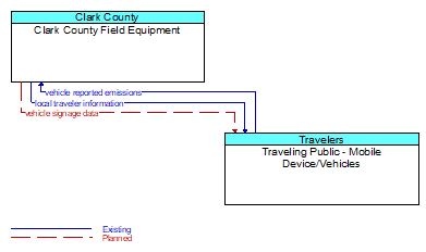
Interface: Clark County Field Equipment - Traveling Public - Mobile Device/Vehicles
Architecture Flow Definitions
local traveler information (Existing) Applicable ITS Standards
Traveler information including traffic, road, and weather conditions for a particular locality. This flow includes the location–specific traveler information and time effectivity of the information.
vehicle reported emissions (Existing) Applicable ITS Standards
Current and average vehicle emissions data as measured by vehicle diagnostics systems and reported by the vehicle.
vehicle signage data (Planned) Applicable ITS Standards
In–vehicle signing data that augments regulatory, warning, and informational road signs and signals. The information provided would include static sign information (e.g., stop, curve warning, guide signs, service signs, and directional signs) and dynamic information (e.g., current signal states, grade crossing information, local traffic and road conditions, detours, advisories, and warnings).